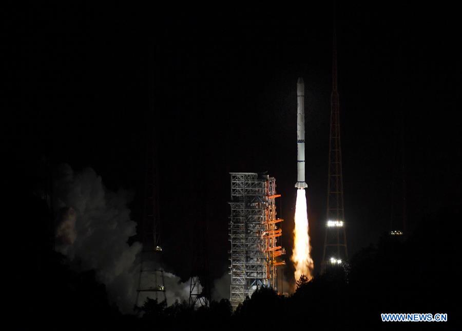
The Fengyun-2H meteorological satellite, carried by a Long March-3A rocket, is launched from the Xichang Satellite Launch Center in southwest China's Sichuan Province, June 5, 2018. (Xinhua/Liu Kun)
XICHANG, June 5 (Xinhua) -- China on Tuesday launched the new Fengyun-2H meteorological satellite to improve the accuracy of weather forecasting and provide better meteorological services to countries participating in the Belt and Road Initiative.
The Fengyun-2H was launched on a Long March-3A rocket at 9:07 p.m., Beijing Time, from the Xichang Satellite Launch Center in southwest China's Sichuan Province.
It was the 277th mission of the Long March rocket series.
A geostationary orbit satellite, Fengyun-2H is the last in the Fengyun-2 series. The Fengyun-4 series will dominate China's new generation geostationary orbit meteorological satellites, said Zhao Jian, deputy director of the Department of System Engineering of China National Space Administration (CNSA).
In response to a request from the World Meteorological Organization (WMO) and the Asia-Pacific Space Cooperation Organization (APSCO), the position of Fengyun-2H will be changed from original 86.5 degrees east longitude to 79 degrees east longitude.
This means the Fengyun series satellites will be able to cover all the territory of China, as well as countries along the Belt and Road, the Indian Ocean and most African countries, according to the CNSA.
The adjustment will enable the Fengyun series satellites to acquire meteorological data over a wider range, improve weather forecasting accuracy and the ability to cope with climate change and mitigate losses caused by natural disasters, Zhao said.
Equipped with a scanning radiometer and space environment monitor, Fengyun-2H will provide real time cloud and water vapor images and space weather information to clients in the Asia-Pacific region, said Wei Caiying, chief commander of the ground application system of Fengyun-2H and deputy director of the National Satellite Meteorological Center.
The Belt and Road region, which is mainly high mountains, deserts and oceans, lacks meteorological information. Damage from natural disasters, especially meteorological disasters, in the region is more than double the world average.
After four months of in-orbit tests, Fengyun-2H will provide data to help Belt and Road countries better cope with natural hazards, Zhao said.
"The move shows China's willingness to construct a community with a shared future," said Zhao.
It also addresses a WMO request to strengthen satellite observation of the Indian Ocean to fill a gap in the region, which is China's contribution to the international community as a major power of the developing world, Zhao said.
China will offer data of the Fengyun series free to Belt and Road countries and APSCO member countries, said Zhao.
China has helped establish ground stations to receive the data in some APSCO member countries, including Pakistan, Indonesia, Thailand, Iran and Mongolia. China plans to upgrade the stations and provide training to technicians in those countries.
If countries along the Belt and Road are struck by disasters like typhoons, rainstorms, sandstorms and forest or prairie fires, they can apply for and quickly get the data, Wei said.
China's meteorological satellites have played an important role in the Belt and Road region. For instance, the Fengyun-2E satellite captured an indication of heavy rainfall in Pakistan in August 2017, and issued a timely warning to avoid casualties.
China already has 17 Fengyun series meteorological satellites in space, with eight in operation, including five in geostationary orbit and three in polar orbit, to observe extreme weather, climate and environment events around the globe.
The WMO has included China's Fengyun series of meteorological satellites as a major part of the global Earth observation system. They provide data to clients in more than 80 countries and regions. Weather forecasts in the eastern hemisphere depend mainly on China's meteorological satellites, according to the CNSA.
Since Fengyun-2A was sent into orbit on June 10, 1997, the Fengyun-2 series satellites have monitored more than 470 typhoons emerging in the western Pacific Ocean and the South China Sea.
They helped improve the accuracy of typhoon forecasting. In 2015, the deviation of China's prediction of typhoon tracks within 24 hours was less than 70 kilometers, among the world's best, according to the Shanghai Academy of Spaceflight Technology (SAST), producer of the Fengyun series.
The new generation Fengyun-4A geostationary meteorological satellite launched at the end of 2016 can improve observation efficiency by 20 times compared with the Fengyun-2 series, said SAST.