LHASA, July 23 (Xinhua) -- Chinese scientists are working on a survey to measure the depth of a major lake in southwest China's Tibet Autonomous Region, sources with the Chinese Academy of Sciences (CAS) said Tuesday.
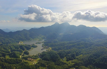
Lake Yamzhog Yumco with an area of about 590 square km is located in Nanggarze County in the city of Shannan. Yamzhog Yumco along with Lake Namtso and Lake Manasarovar are regarded as the three holy lakes of Tibet.
About 70 km away from Lhasa, capital of the region, the lake has become one of the most popular tourist attractions in Tibet.
This is the first time for Chinese scientists to conduct a comprehensive measurement of the depth contours of the lake.
Ju Jianting, a researcher with the Institute of Tibetan Plateau Research of the CAS, said researchers used to only have the water depth data around the lakeshore of Yamzhog Yumco, and they did not have comprehensive knowledge of the lake terrain.
Since the shape of Yamzhog Yumco is complicated, researchers decided to measure in three directions on the lake this time. They will use sonar technology to collect the depth data of the lake and draw the lake bottom isobath. The area and the water volume of the lake will also be measured and calculated with the assistance of remote sensing image, according to Ju.
The survey is part of the country's second comprehensive scientific expedition to the Qinghai-Tibet Plateau that began in June 2017. Lasting five to 10 years, the expedition will conduct a series of studies focusing on the plateau's glaciers, biodiversity and ecological changes, as well as monitor changes in the region's climate.
China's first comprehensive scientific expedition to the plateau took place in the 1970s and covered more than 50 disciplines including structural geology, paleontology, geophysics, climatology, zoology and botany.
Dubbed "the water tower of Asia," the plateau provides the water supply for many Asian rivers including the Yangtze, Yellow River and Mekong River. As the water resources of the plateau are also vulnerable to the influence of climate change, it is important to find out the water storage of glaciers and lakes and the runoff of rivers.
Statistics from the CAS show that the Qinghai-Tibet Plateau has more than 30,000 lakes, covering an area of more than 47,000 square km, accounting for more than half of the total area of the country's lakes. Among them, there are more than 110 lakes covering an area of more than 50 square km, accounting for 67 percent of the total area of China's plateau lakes. However, most lakes lack comprehensive information on water depth and quality.
Zhu Liping, deputy director of the Institute of Tibetan Plateau Research of the CAS, said as of 2017, the second comprehensive scientific expedition has collected the information of depth and water quality of lakes covering about 28,000 square km.
Recently, researchers are investigating the underwater terrain of lakes covering over 50 square km each to learn the comprehensive condition of the water volume of the lakes on the Qinghai-Tibet Plateau so as to lay a foundation for the further research on the interrelation of lakes and the climate, said Zhu.